Tag: Trekking

  • A Guide to Trek Chua Chan Mountain

    A Guide to Trek Chua Chan Mountain

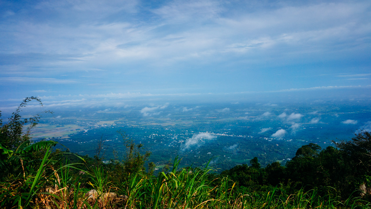
    Chua Chan mountain, the second highest mountain in southern Vietnam, is your perfect choice to hike. Here we go!

    Introduction

    So where is Chua Chan mountain, and why it is so special that become one of HCMC citizen’s most favorite mountain hiking spots?

    Located in Dong Nai, Chua Chan mountain (aka núi Gia Lào) is about 100 km away from Saigon. As 837 m high, it is also the second-highest peak in the southeastern region of Vietnam, just after Black Virgin Mountain (núi Bà Đen) in Tay Ninh, whose height is 996 m. It was recognized as a national heritage site in 2012.

    Read More: Black Virgin mountain trekking tips

    It is interesting that Chua Chan used to be a volcano (so typical is the conical shape), and you may see it when taking a bus from Saigon to Phan Thiet as it is located close to the mainway.

    In Vietnam, wherever there’s a mountain, there are temples or pagodas. Sharing the same fact, Chua Chan is home to three main pagodas: Buu Quang, Linh Son, Lam Son.

    Pagodas at Chua Chan mountain

    Linh Son pagoda (aka chùa Ông Ngộ) was initially a small altar in a stone cave back in 1952. More than a decade later, the official pagoda worshipping Buddha was constructed in 1965, just 150 m away from this spiritual site. The story around this stone cave is quite interesting but warning for dare hikers: it was actually connected to a larger cavern, which is housed to a multitude of little streams running toward a small pond. From this pond, a person could hike downward within 3 hours to the foot of the mountain at Ong Don (Ông Đồn). In the 2000s, there was an enthusiastic hiker traveling through the cave, unfortunately killed by rock falls. Since then, the cave mouth was closed to prevent any similar accidents. The facility of the pagoda is well comfortable for visitors sheltering overnight.

    Sharing the same history as the aforementioned Linh Son, Lam Son pagoda (aka chùa Cô Ba) was built in 1955 as an altar in the case then developing into a full spiritual structure later. The interesting fact of this pagoda is that buddhist nuns have been at the helm of this temple since 1970. At the height of 250m altitude, Lam Son is also housed to various remarkable religious statues and a spectacular vista toward Gia Ray town far far away.

    Located at the height of 600m altitude, Buu Quang (aka chùa Gia Lào) is the highest among the three pagoda at Chua Chan mountain. The history of this temple dates back to the early 18th century, when a zen master named Ngo Chan traveled to this mountain and set up a pagoda in a cave called “dragon cavern” (Long Cốc). Later, he moved to Dinh mountain, but the indigenous people thought he reached the peak of the way, so they closed the cave mouth. In 1845, a monk named Buu Chon came and opened the cave to lead a religious life in seclusion. Nearly a century later, two geologists Van Ngo and Sau Cao discovered the site, and have a monk at the helm of the pagoda, which has been succeeded by generations of monks up to now. The pagoda is conveniently approached, as located close to the cable car station.

    Drive or Ride to Chua Chan mountain

    There are 2 main routes, depending on your transportation: the fastest way is to ride a car/ bus following the expressway, while travelling by motorcycle to enjoy a ride of freedom on 1A highway is not a bad option. Compared to the Ba Den mountain motorbike route, the distance between HCMC and Chua Chan Mountain is shorter, saving more time when your ass is tortured on the motorbike.

    Read more: The Pre-Ride Motobike Inspection For Your Safety 

    By the way, both hiking routes to the summit (tick off Saigon – Chua Chan transportation route to better navigate the Chua Chan hiking map integrated above) are also less heavy breathing than the famous summit of Tay Ninh province. So Chua Chan summit has recently been one of my favorite camping sites in the South.

    Hiking route A: Starting from the cable car station – Pagoda complex

    This route offers quite a comfortable experience, but less natural vibe. Moreover, you will have to pay an entrance fee of 15,000 VND when following this route (Fortunately, the other route B is a local trail and free of charge as no one owns the gate 😀 )

    Trails from cable car station to the summit (2018)

    Instead of hiking, you can buy a ticket to go up by cable car! With 1 km in length, the cable car system hosts 72 cabins (8 pax /cabin), constructed by an Australian company. The surrounding is so colorful with flowers and plants neatly grown and well maintained on a daily basis. A return ticket costs 160,000 VND/ adult and 90,000 VND/ child (0.9m-1.2m) and free for under 0.9m but charged as an adult if s/he is taller than 1.2m.

    The beauty of nature on Chua Chan mountan (2018)

    Still decide to hike? You will travel through various pagodas, some of which are mentioned above. The rest stops are located from time to time to serve a multitude of pilgrims and visitors climbing uphill and down hundreds of stairs. As long as you have money, every comfort can be bought from the side vendors.

    Vendors by the staircase

    The stone staircase upward the pagoda is steep and fully occupied with stores and food stalls. Some vendors might ask you to buy some goods, especially incense and candles if you are Vietnamese or Asian as they think you come to pray.

    2018

    Despite the fact that stores ruin the sacred atmosphere of a pilgrimage, they are beneficial somehow that provide travelling people with delicious food and cool drinks, along with clothes, shoes, souvenirs. Someone says it also hosts so-called “spiritual services” including palmistry and fortune telling cards. Entertaining in karaoke rooms and resting overnight in hostels are also available.

    Yeah, I think the “very special village” plays very well a role of the dedicated food street in a manner of “staircase to heaven”

    Hiking from the upper cable car station (2018)

    The trail

    After leaving the cable car station behind, you start following a paved trail, which is lined with cajus and other lush trees. Be noticed that sometimes forks show no direction signs, and the general advice is to opt to the wider routes as they are likely towards the peak. If you go the wrong way then it is also a very short time to realize that situation and come back, which means, you may get lost, for a while, so no worry.

    Upper cable car station

    This station is very close to two points of interest: Buu Quang pagoda (I thought this transportation was built mainly to serve the pilgrims) and paragliding cloud base (I took off several times there, a very challenging spot for any rookie pilots for sure). You can buy bottled drinks and ice-cream by a vendor inside the station during the daytime for at least 15,000 VND for a 500ml bottle of coke. But for the first time hiking, my friends and I experienced pretty bad weather and finally decided to pitch tents here. How remarkable it was there!

    Indeed, the station is hardly occupied by campers but we did it and enjoyed a wonderful night. The next morning, someone told us that the night watcher thought it was the devil as he heard our laughs but failed to see us. LoL! I will tell you the detailed story in the “night trekkers” part below.

    For night trekkers

    As we planned to camp at night, the experience was totally different from day hiking.

    It was a little bit weird.

    Starting at 10 PM at the foot of the mountain (10,000 parking fee/ night at a nearby house), we saw no one while taking step-by-step to the peak, but some prayers when we were close to the pagodas. Dogs were everywhere and they were barking fiercely but nicely without any bites.

    The vendors were just resting on beds or hammocks but you hardly see them, little altar along with the smell of incense. After the pagoda, we experienced a complete darkness of the trail. It should have been one or two hours to hike uphill to the summit, while the weather turned worse and worse. That’s why we half-heartedly pitched camps in the upper cable car station.

    If you don’t want to take risks (due to weather or so) then camping in the cable car station at night is pretty ideal but you may need a permit.

    Taking off from Paragliding Cloud Base (2020)

    Chua Chan Paragliding Cloud Base

    Flying games has so far become one of the most sought-after adrenaline activities for thrill seekers around the world. They don’t come at cheap price, but are frequently mentioned in the bucket list of most world travelers, say skydiving in Fiji, ballooning in Turkey, Laos, or bungee jumping in Macau, New Zealand. People are often willing to pay a fortune, even when they travel on a budget, for their once-in-a-lifetime experience: flying.

    If you have ever wished to fly in Vietnam (of course, not by domestic airline), we have both good and bad news. The good news: there are paragliding services in which you will be a passenger, flying together with the experienced pilots. The bad news: There are very few “airfields” to take off in the S-shaped country.

    Though the mountainous terrain of the North seems to offer more opportunities to paraglide, the situation in the South contrasts, due to the popular terrain is a vast delta dotted by several mountains once being volcanoes, one of which is Chua Chan. By the slope of this mountain, a small cloudbase airfield was established for the local paragliding community as well as curious visitors who would love a romantic flight accompanied by high-trained pilots.

    As a rookie pilot years ago, I myself took off here for the first time and admired the majestic view from above. Trekking would not give you that experience. It is completely different. It’s high, fantastic, yet a bit scary when your feet are entirely up in the air, not heavily stuffy like in a closed cabin of a commercial plane with limited window-sided seats. Paragliding offers passengers a remarkable panoramic experience, no limited sight. Turn your head and you can freely admire the whole stunning landscape with the bird-view toward the surrounding regions, a train rolling far away, a green forest of cashew trees at the foot of the Chua Chan mountain. It is definitely a must for dare travelers who seek a high dose of adrenaline in extreme sports in Vietnam.

    To book a seat on paragliding wings, you can contact via the fanpage of Chua Chan Paragliding.

    Wooden house by the spectacular view

    En route to the peak, you probably stop by a cottage hosting many hammocks for beautiful resting. Actually, when we came here in 2018, we saw a little garden full of baby pine so it is hopefully expected to be very green the following year. (I didn’t follow this route in my 2021 trip, so I have no idea how it has progressed so far).

    You could set up camp and cook there, a lot of campfire traces on the ground and you can collect big stones nearby for a temporary campfire. From this cottage, it may take you one more hour (or less, depending on your stamina) to reach the summit, completing the hiking route A. Congratulations!

    ‘Electricity Pole’ Hiking Route B: Easy game, less vendors, more nature

    This route takes about 2-3 hours trekking with a lot of short breaks to refresh on big stones, under green canopy with great views towards a small lake far far away. Less stamina required (and more time to rentertain at the summit).

    There has been no commercial complex yet here (Ba Den summit now is occupied by the recreational park of Sun World – a significant property of Sun Group, the brand behind Fansipan Legend in Sapa, Lao Cai and Ba Na Hills in Da Nang). Last but not least, the service for camping in Chua Chan is excellent.

    Like Ba Den, at the foot of the mountain, there are a couple of locals who provide rental service and rest stop, parking lots. You can simply bring along a load of money and rent everything, from tents (diverse sizes), mattress, sleeping bag, flashlight, campfire kits, and other popular outdoor gear. Travelers resting on hammocks here, chilled drinks in hand, chit-chatting with companions before/after a hike are frequent on the weekends and holidays here. You can even get showered with a little additional fee.

    Often called “electricity pole route” of Chua Chan, the hike here bears a resemblance to that of Ba Den mountain, with a rock-stacked trail following the utility poles to the summit. The path is clear, lowering the risk of getting lost, while sometimes surrounded by a dense canopy of local trees, some of which are banana, cashew and bamboo.

    A wide array of signs to raise the community’s awareness of environment protection are also erected or hung on trees and poles along the route, like the trekking in Ma Thien Lanh and Ong Rong of Hon Son Island, Kien Giang. So the path is kinda clear to navigate in the daytime, but the possibility of getting lost at night should be highly considered. I would recommend hikers to start climbing from around 4PM, as the sunset is great while you are on the slope, navigating everything easily.

    You would also pass a water reservoir near the top. This essential supply is usually used by frequent hikers to refill water, which is absolutely a big plus compared to Ba Den mountain. Boiling this water with a camp kettle and you are no longer worried about dehydration in case the carried water is low.

    Campsite at the summit of Chua Chan mountain

    Depending on the season, the land is colored by green or yellowish brown look-like burnt grasses or lush plants. The breezes lure you into a calm nap with floating clouds rolling by near and far.

    It also provides a spectacularly panoramic view downward the neighborhoods below. (This is absolutely different from camping by the beach, like the campsite in Ho Coc, Ba Ria-VungTau).

    The campsite is pretty large, possibly hosting up to more than a hundred hikers without problem. The strong wind is definitely a great factor to consider where to pitch camps.

    So if you travel in groups or family camping with more than three tents, erecting in the open is ideal, as the tents cover themself against the wind.

    Only one to two canopies? Let’s set up among big rocks or behind a line of trees to protect your campfire better.

    The fuel is often available, but requires some effort to seek after all. Wandering around and you may come across a few dry logs scattering here and there over the summit.

    Note: The dry elephant grass is a super flammable material and should be used carefully, especially when your site is surrounded by the high density of grass. Any carelessness could set the accidental fire and the spread is rarely well controlled then, as the grass is FLAMMABLE!

    At the highest rock there is a pyramid etched with the mountain name and altitude “Chứa Chan 837m“, attracting a multitude of hikers to check-in at dawn (and sunset).

    Jump on this to pose and the panorama is such a well-deserved reward for the whole tiring trip uphill before.

    Bringing home some souvenirs, why not!

    If you go downhill on route A, some souvenirs for family at home (and colleagues in the office) would be great to celebrate after the trip. It’s definitely crunchy banana chips with ginger that is a specialty as you see many many of them on the way back and local vendors.

    “What’s your plan”

    A typical itinerary and time schedule for a day trekking should be like below:

    5:00: Departing from Ho Chi Minh City

    6:00: Have a breakfast (in Bien Hoa city)

    9:00: Reach foot of the mountain, park your motorcycles (if any), prepare your backpacks and get ready to start the staircase journey.

    9:30: Starting the hike, head to the pagodas

    10:30: End of the staircases, reach the pagoda, take rest then start the mountain trekking

    12:00: At the summit, have lunch, take nap

    14:00: Start descending

    15:30: At the foot of the mountain, have drink and relax

    16:00: Ride back

    17:00: Have dinner in Bien Hoa city

    17:30: Continue riding back to HCMc

    19:00: In HCMC

    For the night hiking, generally share the time schedule, if you departs from HCMc at 16:00 then you’re likely to reach the peak at midnight and welcome the sunrise at dawn on the next day (luckily you see a stunning sea of cloud) and get back at 8:00 then arrive in HCMC at 14:00 same day.

    What kind of outfit should be good for the hike?

    Pants and long sleeves are better as the trail has a lot of tall grasses that makes you irritated, along with mosquitoes.

    Weather does matter. We had a very bad rainy night and couldn’t make it to the summit, so, you’d better watch out for the weather forecast before departure. The dry season starts from December to April, and rainy season is between May and November. It’s safe to trek in the dry season but packing along a raincoat is usually a good idea.

    The path is easy to go, and it may have a little muddy terrain in the rainy season that probably makes you fall.

    It is extremely comfortable to wear sandals in the rainy season. Normally, trekking shoes play pretty well, too.

    Wanna protect your skin? A sun cream is perfect, though mostly you are covered by the shade

    If you plan to camp overnight then an extra clothes to change is advised as it keeps you dry while the cold and fog at night may make you get sick.

    Hiking Chua Chan Mountain on a budget

    100,000 VND Gasoline

    35,000 VND/ a bow of Pho (good option)

    10,000 VND/day parking fee (per motorcycle)

    200,000 – 300,000 VND self-prepared meal for one person at peak/ camping

    30,000 VND water (3.0L)

    10,000 VND raincoat

    320,000 VND in Total ($15)


    Chua Chan mountain photos

    2018

    Chua Chan ZaiTri
    The Upper Cable Car Station
    A flower pot by the upper cable car station

    2021

    Further Reading On Trekking & Camping

    Stunning views, cozy campfire, friendly talks, we all love trekking and camping experience. I also list some selective stories and tips below for your further reading.

  • My Fansipan summit travel story

    My Fansipan summit travel story

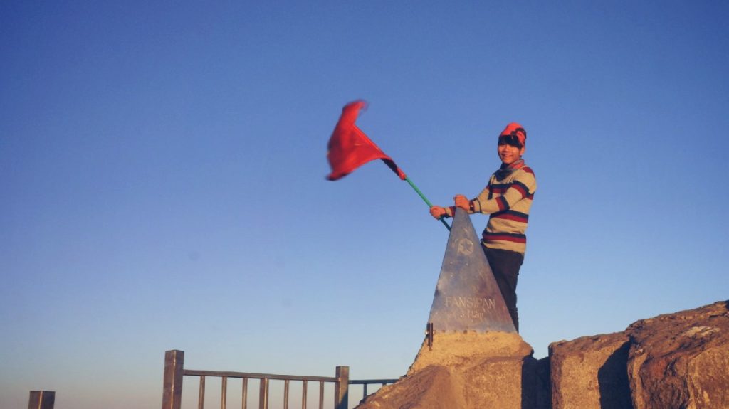
    If you are a trekaholic, when you visit countries, what would you be? The highest summit – rooftop of the country or certain region, right?

    When you in Lao Cai, a north-western province of Vietnam, don’t forget to trek the rooftop of Indochina – Fansipan summit, at the height of 3143m above sea level. The summit is always the most attractive destination for not only for the local but also travelers around the world. 

    And I really would like to tell you my Fansipan travel story – majestic and fanstatic!

    Prologue

    Despite a solo traveler, I didn’t choose to go alone this trip. Especially I heard the news that there had been a foreign trekker found dead months before. The poor guy really made an impression on how hard the incoming challenge would be. So I chose an safer option, that to go on a tour.

    I booked VietDiscovery a tour of climbing Fansipan, 2-day-1-night, and price was reasonable: 50 usd, [link] the lowest one compared to the other. The introduction was good, especially when my friend suggested me a group of Fansipan hikers, which connects to the company. I believed this company was trustful.

    That was my first time conquering the roof of Vietnam so it was excited but anxious a bit. I wasn’t sure that my health was able to fulfill the trip, I just kept in my that I had to make it, because one simple reason: we are born to do new things everyday and challenges make our life worthy.

    Day 1 – trekking toward 2800m camp

    Preparation at agency office

    I woke up early, eager to the lifetime experience. Not as the day before, with a dense of fog, It was very clear, expected to have a sunny day of trek. I took a taxi bike to Sapa town for 30000 vnd. What a nice deal!

    It was sunny in the city center. The agency office was very busy preparing for a trekking day, I saw them bring fresh chickens, pork, cooking oil, some veggies and water, which are necessary for a trek stop. We were also issued some personal stuff like a paper roll, raincoat, 4 bottles of water and a toothbrush along with a tiny paste tube.

    “Crews” on trip

    I made friend with a girl named Tra. She’s cute, big a bit and very open-minded, a typical travelers. Her English was good, I really admired her for the self-study. Ah, she also made two Vietnam bicycle trip (so shame that I haven’t made it).

    During the trip, I also fell in friendship with Monica from Poland (she’s really good at hiking with an excellent base health), Daniel (and lovely Filipino guy) and Sunny (an American teacher, solo female traveler, you’ll admire her for what she’d done) and a group of young people, who are staffs from THE KAFE in Hanoi, they are cute, adorable and funny all the time.

    We had a tour guide named Tung and two porters are Trung and Vac, who are just teenagers. They are very cute and I honestly miss them after trip.

    Tram Ton station – the beginning

    We started the journey at Tram Ton station. When you ride via O Quy Ho pass, you see a complex named Love waterfall, that’s it. The station is 1945m at height, so it’s the shortest and fastest route to the summit.

    The dry day made it very easy to do trek, the path was clean and very clear to follow. Sunshine shot through leaves, coloring the ground with green. My guide said that the weather was rarely so those day, I was a lucky boy. Yeah, thank God for the blessing.

    Though our crews included porters, we didn’t have them carry our backpack, everyone held a strong will and do-it-themself whole the time, so the porter’s main task was to guide and support people though.

    After a short hike, we rested in a plain ground, and people did selfie, it was very happy when you were surrounded by energetic people, making the trek more funny and memorable.

    There’s a stream crossing over the path at the beginning. Because it was a sunny day in dry season, so we passed it easily. Imagine its fury in rainy season, oh, so furious and dangerous!

    I was impressed by sceneries here: sky was clear and blue, fantastic ambiance made by sunlight, ancient trees with giant, twisty roots, even shades also contributed greatly to the beautiful path. Some dead trees are really tasteful if you can shoot them at right angles.

    Every time you climb higher, you have chances to change perspective and the landscapes are different, as well, which make it more exciting to keep going and explore something new ahead.

    The path from Tram Ton station to 2200 height was quite ease and enjoyable, stairs built neatly so you hardly get lost.

    2200m-height camp

    This is where we had our lunch. After a long trek, any food you consume will own a beautiful taste, because you are in a great hungry pit. But we had to wait for nearly 30 minutes later that the tables were clear for us. Many trekking groups joined that day which made it quite a “traffic jam” at the camp.

    There was a fatty cat walking around and to be honest, I did love it. I wanted to hug, tease, feed him (I didn’t really know his gender, who knows!!).

    We did enjoy the meal, there were boild rice wrapped in silver screen, fish sauce, chicken cooked with sauce, boiled egg, cabbage,… it was not a party but really delicious, loud and happy. People were talking to one another, making the dining more “entertaining”.

    We had a while to rest. I stayed awake and strolling around whistl foreign friends and Tra were talking, sharing theirs stories. I just enjoyed the precious sunbeam landing on my skin. It’s so “expensive” there, while fog were waiting all the time to hide my sun.

    Here we go again!

    The upcoming path would be more challenging, some of the trekkers who had just been back from the summit told me so. They said that the path from 2200 height to 2800-height camp was very hard ascending, so more fatigue. It was, as they said.

    The sun was high, atmosphere drier and no more fog surrounding, no more fanstatic sense. After an hour away, we stopped another plain ground, which offers a panoramic view of mountain range, it was breath-taking and I couldn’t stand shooting a panoramic photo, here it is:

    The group of young people from The KAFE – most of member are beginners, I think – were hiking slowly. They were really fatigue after a long trek because of not getting used to the pace. That’s why I think the practice before a trip is very important, especially when you do trekking or some games which require much physical strength.

    The path features a cliff (indeed, it’s not a cliff but from a right angle of shooting, it makes an illusion of height). Tung – our tourguide showed us that was able to reach it firstly, by moving like a artful jumper and landing safely at the cliff, making everyone breathless.

    Then Daniel joined the posing show, later is Sunny. It’s really exciting to get there, though the strong winds with its severe cold make you think carefully before putting steps.

    Our group was not the same completely, someones strong, someones weak, so after all, we were usually splitted up in to 2-3 groups, guided by Tung, Vac and Trung. The stronger went first, and got the rest ground soon, then waited for the weaker.

    In the late afternoon, the sun gradually turn into orange, which made the landscape more amazing. The trail was sometimes changing the color, as if neckos stick to every pieces of forest. They were all beautiful: rocks, trees, roots, bamboos, bushes,… it was cool down, and I felt so energetic again to conquer steep stairs. It’s very weary, but worthy.

    Indeed, my body turned hot overtime, so, despite the very cold atmostphere at that time, I put off most of my warm clothes, but a slim t-shirt. But by the time we rest at the stop, my body temperature got balance and I had to dress up a bit to remain warm. Staying healthy when doing a trek is very important because the support is rare in remote area like mountains.

    I was surprised that when we hiked high enough, it’s true that we could see the horizon at far, in a very clear day. The mountain range then piled like a giant sand dunes painted by green, so gorgeous, splendid and majestic!

    2800m-height camp

    When the sun was nearly down for his sleep and the light drew back to hideout, I reached the second camp, at 2800 height. Just few people of my group did it as soon as I did, so we had to wait for the rest.

    It turned very cold and windy at camp. At first, I ran into a dorm to hide from the winds. But there’s a crowded fire-camp outside and there’s no reason not to join them. By the way, the fire could warm up me. So cool!

    They roasted pigs and chicken. The flames were big and the smell was really tasty. I was very hungry at that time, you know. After a long trek, my body got tired and the promising delicious food was really a curse. Haha.

    I tend to wash my hand with the water but when the tap was running, I pulled my hand out. The water was so cold that it was possible to make an ice-burn. There was a makeshift canteen selling mineral waters, energy drink,… but the price was double/triple so I used mine.

    The campfire was very warm that I could heat my body from-top-to-toe while waiting for my group. There were a group whose members were up to 50 people, and they were very exciting sharing their painful experience to entertain the other, that was good. Sometimes I joined their joke.

    What a cold night!

    Very long time later, our friends reached the camp. They looked so tired, but full of happiness. The guide finally led us to our dorm and we could unpack. It was so so weary and hungry, and it went dark quickly. Someone brought along a tiny travel stove fuel by alcohol and she boiled water to make coffee while sharing some heat to the companions. It was nice.

    To prepare for a definite cold night, we set up our belongs. Sunny used the heat patch for her back and really cool, I used it when I slept to find some precious warmth. Some people hang their flashlight to light up the room, which was very useful in the dinner later.

    And when we rested for a while, then our dinner was served very in time. We had tofu, pork, chicken dish with small bowl of fish sauce. Very simple but extremely delicious. I found a theory that instead of having a delicious food, you can very enjoy your meal when you in a great hungry. It’s true!

    After dinner, because the extremely cold atmosphere outside, we almost got into issued sleeping bag and enjoyed  the warm while trying to close eyes. I recharged my devices and reviewed all the media I recorded on the day. They were so nice.

    Outside, the sky was very clear with milions of stars shining bright. I loved them so much.

    Day 2 – to the summit

    Trekking at dawn

    I just slept a bit at previous night, better than ones who couldn’t stand the freeze causing them headache and a red-eye night. I didn’t know that until the morning, they confided the truth, which made them weary quickly by the time.

    Around 4AM, Tung woke us up, and prepared our breakfast. Everyone seemed awake all, no sleepy sound was made. 15-20 minutes later, everyones finished their personal hygiene and packed up belongings. Then the hot breakfast came in. After a frozen night, everyone loved the meal. It brought us heat and energy, they were not delicious dish but in our case, they were super tasty. The situation really made sense. After that, we had a hot coffee to stay awake physically.

    I came out, it was really cold. The sky was super clear, promising for a nice trek. It’s very dark and we had to use our flashlight to see what ahead.

    There were a group who had started before us, so crowded. However, gradually, they couldn’t keep the pace and slow down, which meant we passed them easily. It’s very dark, but my sight was still good enough to see stars above, Sapa town far far away below and they were seperated by a blurry horizon. I had to dress warmly, every pieces of my body touching the dawn cold made me frozen, a sense of cold-burn. I used a scarf to cover my nose, keep my breaths warm. It’s very essential if you don’t want to get cold easily.

    The first step was not tough, but some spots would be slippery a bit due to the moisture and small stream along the trail. Halfway was good, but the rest was more challenging because there was no clear path, and we had to climb by hands as well. Some steep slopes downward really made us carefully and slow down the pace for some times. Finally, we splitted up again, when Tung waved us to stop, we were only me, Daniel, Sunny and Monica as a leading group, the other were so slow. I asked Tung whether we should wait for the rest of team but he said there was no need because the 2 porters could lead them rightly and we were late to watch sunrise at the summit. So we had to hurry up.

    From time to time, we saw a small water pool at side of the trail, made of plastic screens to get water from rains and condensed fogs, it was very clear and cold, some one said it was drinkable. I tried once, but I was not sure about the hygiene, while I still reserved a lot of water.

    When we saw a station lit up by orange color, my guide told us that we nearly reached the summit and just 30 minutes or so and we would put our feet on the rooftop of Vietnam.

    That’s news encouraging us to keep forward excitingly.

    Final steps

    5:30 AM, we saw a little lights from the east, they divided the sky into two half: light above and dark below. Then everythings got clearer and we could turned off our flashlight while it was still possible to trek in low light condition.

    Some times we had to climb up metal ladders, which was very cold when I touched. Some times we climbed over trees growing horizontally blocking the path. It was tough a bit. When the strong sunbeams appeared, bringing us more vision, we saw cables were moving up and down, bringing staffs and stuffs, I thought so.

    When approaching 3000m in height, we saw a construction site – Fansipan legend, a tourism complex – looking like a strict fortress.

    The high we were, the less oxygen we could breath, yes, it got more and more fatigue. It was really a fight against your will and the body. I just kept going and followed the tourguide, if he could make it, so could I.

    Finally we made it. Yesss, we made it!!! We reached the complex at late 6 AM, so the sun rose just a bit higher. There’s a barrier blocking you, just passing it and we. Despite tiredness, I tried as quick as I could to climb upstairs but I had to wait again to recovery my stamina, it was really tough, and I had to touch the summit, I had to do it…

    Fansipan conquerors

    6:30AM. I was stunned by the landscape mother nature showing me then: all the clouds were staying below me, like a vast ocean that we usually enjoy at shores and right at the center, the sun was shining so bright, as it possibly blinded me but I couldn’t stand watching a sleeping beauty waking up after a long dark night.

    The sun was really like a princess attracting thousand of people to watch her getting up. Wow!

    My fingers was almost frozen, though I tried to heat them by sunbeam uselessly. It was too cold at the summit. I walked around and enjoyed my victory and thought of all the challenges I passed. Oh ops. I forgot to take a picture with that trophy – a paramid engraved with words “Fansipan – 3143m”.

    The ground was made of wood, so it look quite natural but indeed, I didn’t expect so many man-made objects at the summit, making it like a garden that you pay 600 000 vnd to touch at ease.

    I took photo for Sunny, she seemly loved the gorgeous sceneries and Daniel intentionally took photo himself – an instagram-aholic. Afterall, we had a photo together to memorize these experience. That was a moment of lifetime.

    Way back

    8AM, sun was high and shiny above the sea cloud. It was getting hotter while cable cars were bringing more visitors toward the summit. When the summit base was full of people, and we had enough rest to get back.

    But some of us chose to use cable car, including Sunny. That was the best route to save more time and stamina, but you then had to take taxi back to town.

    For the way back, it didn’t take us much time to go back because of slopes downwards. I had chance to see what I hadn’t seen when on the way to the summit due to the dark. It was really nice when you lost in fog again, sometimes alone among forest, so peaceful. And I sang my favorite, enjoyed my life so deeply. I love it, my youth, because, you only live once, so live full.

    Epilogue

    My first attempt was fascinating, I really enjoyed it. However, there are still other routes more challenging like Cat Cat village route or Sin Chai one, hopefully I had chances to trek these ones.

    Fansipan is a must-have experience, you travelers. Book a trek tour or do-it-yourself and you won’t be regretful for what you got.

    After trekking Fansipan, Biking around Sapa is also a nice choice. Rent a bike and conquer Sapa steep roads!!